The recent Ontario Superior Court decision confirming the Saugeen First Nation’s rightful ownership of the north section of Sauble Beach is in itself an important milestone in Canada’s path toward meaningful reconciliation with Indigenous people.
Possibly just as significant in the future is the potential for a new, or renewed, era of improvement and development in all aspects of Sauble Beach’s well-being. Above all, that would include protection of the natural environment, and a new vision of future development that honors the longstanding First Nation presence and the principle of reconciliation.
I say ‘potential’ because it all depends on how open to, and how well, the indigenous and non-indigenous communities work together to make it happen. In other words, will there be peace and reconciliation, and cooperation for the overall good of the beach and both communities? The answer to that question will be nothing short of a litmus test for the future of Canada, as well as the future of Sauble Beach. There is far more to be gained by thoughtful cooperation than resentful confrontation.
Such an approach could be applied to the most mundane aspects of Sauble Beach’s future, as well as the most noble. One thing that comes readily to mind is Sauble Beach and the surrounding communities are long overdue for water and sewer services. The Saugeen First Nation and the Town of South Bruce Peninsula may want to put their heads together and join forces as soon as possible to call upon the federal and provincial governments’ help to make that a Sauble Beach development priority.
The court decision has set the stage for an interesting, new dynamic: the interface of an Indigenous community with considerable experience hosting non-indigenous tourists and cottagers on its territory, now sharing with a municipal government the well-being of a major tourist attraction and the mostly non-indigenous, business and residential community built around it. Respectful cooperation is surely the order of this new day.
In all the circumstances, and considering what’s at stake, it’s a wonder the long-standing, Saugeen land-claim didn’t get far more news media coverage and public attention before news of the court decision broke early this month.
The case, based on the Saugeen First Nation’s long-standing claim of ownership, has been before the Ontario court since 1995, but its roots go back 169 years: Treaty 72 was signed under controversial circumstances on October 14, 1854, after a hastily arranged day of intense negotiations engineered by Laurence Oliphant, the newly-appointed Superintendent General of Indian Affairs for Colonial Canada. Oliphant warned the Saugeen Ojibway (Chippewas of Nawash and Saugeen first nations) chiefs that the Crown might not be able to keep squatters out of their Saugeen Peninsula territory as he pressured them to surrender most of it. Yet, later the same day, after the treaty was signed, Oliphant posted a public notice and ordered the Owen Sound-based sheriff to keep squatters out of the newly-acquired Crown territory. The peninsula was soon renamed the Bruce Peninsula after a colonial official who had never been there. The Saugeen Ojibway were to be left with a few relatively small reserves, including the Saugeen First Nation reserve on the Lake Huron shoreline from the Saugeen River to Chief’s Point at the mouth of the Sauble River north of Sauble Beach.

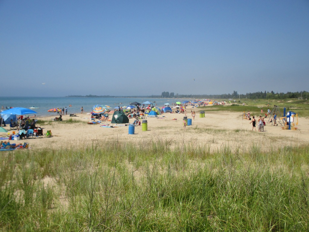
Prior to the recent court decision, the Saugeen First Nation had long claimed the survey done two years after the treaty was signed did not correspond to the intent of the treaty. Ontario Superior Court Judge Susan Vella agreed in her finding that the honor of the Crown had been brought into disrepute by the mistaken survey, and the Saugeen First Nation was the rightful owner of that north portion of the beach that has been under local municipal jurisdiction for many years. Meanwhile, the southern portion of the beach, south of the iconic Sauble Beach signpost, has been Saugeen territory since after Treaty 72 was signed and surveyed.
There was an opportunity for a negotiated settlement of the Saugeen First Nation claim of ownership of the north section of the beach in the summer of 2014. With the support of Canada’s federal government Justice Department, and if its ownership of the disputed section of the beach was recognized, the First Nation was prepared to enter into a co-management agreement with the Town of South Bruce Peninsula; but that deal ran into a fire-storm of public opposition from many in the largely non-Aboriginal community of Sauble Beach when it was presented and discussed at a public meeting in August, 2014; and as a result the court case continued unresolved for another almost nine years.
That was an opportunity lost; but another, similar opportunity presents itself now.
South Bruce Peninsula council has chosen to file an appeal of the April 3 court decision; but it appears to be focused on clarification of the western boundary between the newly confirmed Saugeen territory and the municipality, and the status of private property on or near the north section of the beach. Fair enough; but it’s time to move on to that new opportunity.

The news that South Bruce Peninsula is appealing the Sauble Beach decision does not bode well for reconciliaton. Why can’t the issues the mayor says are outstanding (lands to the east of Lakeshore Rd and Lakeshore Rd itself) be negotiated between Saugeen and South Bruce? What is a court going to say about those things except maybe tell the parties to work it out?
If insanity is doing the same think over and over and hoping for a different result, then it’s time for the town to relax, put the lawyers away, and talk to the neighbours.
LikeLiked by 1 person
The many mistakes you have made regarding the facts in this article shows how little you know about the survey of the SFN #29 reserve. The treaty was signed on October 13th. The survey of the reserve actually began that same October by plotting out the 9 1/2 mile measurement, along with a preliminary survey of the western boundary. The east boundary was completed September 1855 because the western boundary was under dispute and the correction was not approved until August 1855. The final map was submitted in 1856, but the survey itself was not conducted two years after the signing of the treaty.
The offer made in 2014 was no different from the outcome of this trial. SFN would have owned the beach and they would have had veto representation on any decisions made regarding the beach on a 5 member beach management committee. Three SFN members to two TSBP members. How was this a good offer for TSBP?
You say the reserves created by Treaty 72 were relatively small. Small compared to the Bruce Peninsula? Is that what you mean? There is currently 1500 people living on the Saugeen Reserve and there were far less in 1854. Many of the FN people that live there were invited by SFN to come there from the United States. Reserve # 29 is a huge amount of land for 1500 people especially when you consider they also have Chiefs Point and the fishing islands as part of their territory. There is a small village on the Saugeen reserve plus leased cottages along the shoreline. The rest of the reserve is basically untouched and undeveloped. Same goes for Chiefs Point. Why is this much land not enough to sustain and support the SFN people?
Thanks for contributing and being a part of revisionist history. You continually report only what fits your bias and disregard the rest. The survey of the Saugeen Reserve was done correctly in 1855 and there is evidence to prove it that is being ignored.
LikeLike
Thank you for your comment, David. But I fail to see the ‘many mistakes’ you speak of. In fact, Treaty 72 was signed at 1 a.m. on October 14, 1854 after a day of negotiations on October 13 that went on past Midnight. You’re right, I could have worded the teiming of the survey better, by saying something like it took two years to complete, instead of being ‘done’ two years after the treaty was signed. I did not set out to re-litigate the the trial as it pertained to the boundaries or the survey, but to speak to the future in view of the court decision. Yes, I meant ‘relatively small’ compared with the FN’s former territories, includng on the peninsula. I respect your knowledge and point of view, and would never speak disrespectfully to you.
LikeLiked by 1 person
This is directly from the report from Heidi Bohaker, historical expert for SFN at trial:
“Treaty 72 was signed on October 13, 1854, at 1:00 in the morning. Following the signing,
Oliphant reported that everyone walked two miles to Southampton…”
That is where I took the information from, so if what I said is incorrect, it was taken directly from SFN’s expert report.
I disrespect that the truth of this matter is being manipulated, hidden and not acknowledged. I feel that you are contributing to this and yes, I have no respect for that. I don’t think that it is deserving of respect. It is what you are portraying yourself as being against, yet in this case, you are only interested in presenting one side of the facts.
If you never acknowledge my point of view and only support the SFN by cherry picking selective information, how is that being respectful of my knowledge? Do you know that OSST and other news outlets have been reporting incorrect information about the 2014 beach management committee for several years? Claiming that it was to be a committee of equal representation between SFN and TSBP. This is an example of misinformation that leads to a manipulation of the narrative. It’s happening all of the time these days.
LikeLike
Bohaker was wrong. It makes no sense to say the treaty was signed in the early morning hours of Oct. 13. She misspoke. As I recall, David, Scott Dunn of the OSST did good, thorough work in his reporting of your evidence. Too often critics of the news media don’t give credit where it is due.
LikeLike
Unfortunately, I lost your last comment inadvertently and did not hit ‘undo’ in time to retrieve. But I wanted to say, re the date of the signing of the treaty I did a google search, ‘laurence oliphant treaty 72’ and got a timeline of events from the evidence presented from the trial of the larger SON claim. On the ‘question’ you asked, of course I think the trial in such matters should thoroughly consider all the available evidence, and precedents, up to and including the Supreme Court. And if it does not, that is a serious omission.
LikeLike
“Lost” huh?
So, in your estimation, is the omission of the evidence I have uncovered a serious omission? Or, are you with the “you’re not an expert” crowd, and nothing I say has any value anyway?
LikeLike
Yes, David, it was accidental, and I admitted that, expecting you would appreciate my honesty and understand how things like that can happen; but apparently not. Instead you continue with your disrespect. Enough, David.
LikeLiked by 1 person
You have written an article and I have take exception to it. I have expressed my opinion about what I find misleading and incorrect in your article. I pointed out directly why I disrespect how you have gone about this. I have asked you several questions to which you either won’t respond to or you retool the question so you can answer it more to your liking. That is why I found it suspicious that you lost my comment. You changed the context of my question while anyone viewing your answer would assume you answered the question the way I had asked it.
I find there is a pattern of omission in the way you carry on a discussion and that is not only disrespectful it can be interpreted as arrogant. I’m surprised you have allowed any of my comments because you haven’t in past articles. You either don’t want to address certain issues or you feel they are not worthy of your attention. I can’t be sure which it is. Perhaps they are just bothersome to the “why can’t we all just get along” narrative you are trying to create. Why do you have such a hard time accepting that maybe there is another side to this story? That maybe, just maybe, everything was on the up and up when Rankin did his survey in 1854/55 AND, Canada and SFN, 170 years later, maybe, just maybe, have made some major misinterpretations of the evidence.
Questions: (and I ask respectfully that you answer them the way they have been asked. I also ask respectfully that you answer them)
Do you think that the Copway Road agreement was an amendment to Treaty 72 or a separate agreement unto itself? In other words, rather than an amendment there were really two treaties, Copway Road and Treaty 72.
Do you agree that it is 9 1/2 miles from the original SFN western boundary along the shore to midpoint Lot 31? Nine and a half miles being a term of Treaty 72. If so, how do explain this coincidence?: that it is also 9 1/2 miles from Copway Road to Lot 25/26… the amended shoreline boundary. Is it just an amazing coincidence or was this the intended negotiated shoreline boundary which the Copway Road Amendment corrected from the incorrect original 9 1/2 mile shoreline measurement.
Do you agree that it is possible that the phrase “increase in frontage on Lake Huron” taken from the Copway Road Amendment does not necessarily mean an increase to the length of the shoreline?
Do you agree that the phrase “terms of the treaty” is not necessarily synonymous with the phrase “words of the treaty?”
If someone matched the “terms” of Treaty72 to Rankin’s illustration of the SFN reserve on the final map, would you agree that it is conclusive, or at least as conclusive as we are ever going to get, that SFN received the boundaries they negotiated?
LikeLike
This from the Ontario website: https://www.ontario.ca/page/map-ontario-treaties-and-reserves#:~:text=Treaty%2072%20was%20signed%20on,and%20representatives%20of%20the%20Crown.
Treaty 72 was signed on October 13, 1854, by First Nations residing on the “Saugeen Peninsula” and representatives of the Crown. The Treaty area covers most of what is now known as the Bruce Peninsula.
LikeLiked by 1 person